The damaging wind threat is going to be real today, as 65 mph wind gusts are possible along with a heavy, soaking rain for much of the region.
What’s Coming?
The National Weather Service says a brief period of wintry mix, followed by heavy rain, and very strong, damaging winds are forecasted.
The precipitation will then transition to heavy rain by evening, but along with that will be strong, potentially damaging winds. Sustained winds between 35-45 mph are forecasted, along with gusts that could exceed 65 mph. The late-afternoon and early-evening hours is when the greatest risk for damaging winds will persist across the region.
")
Impact and Warnings
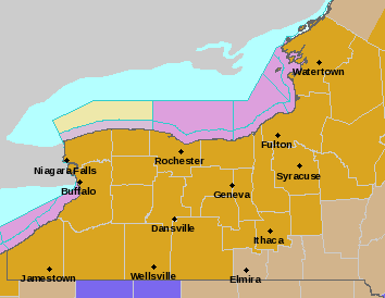
The National Weather Service has issued a High Wind Warning for nearly everyone in the region – including Cayuga, Seneca, Steuben, Ontario, Onondaga, Livingston, Wayne, Yates, and Monroe counties. These areas are expected to see the strongest wind gusts out of this system. The Warning runs through Wednesday morning.
The New York State Thruway Authority has preemptively banned all empty tractor-trailers and tandem trucks on I-90 from Exit 36 to the Pennsylvania border beginning at 10 a.m. Tuesday. This runs until the state cancels it.
Local Resources
Radar
Looking Ahead
There’s going to be another system worth watching as we close out the work week. While details remain unclear – the National Weather Service has its eye on a system that could bring a mixed bag of precipitation, or heavy snow – depending on its track.
Read the full article here
Leave a Reply