
Hurricane Lee isn’t currently predicted to make landfall — but all eyes will be on the intense storm’s path as it slows down near the U.S. East Coast and Bermuda.
National Hurricane Center
Hurricane Lee has grown shockingly fast, and it’s not done: its winds are forecast to top 180 mph by Friday evening.
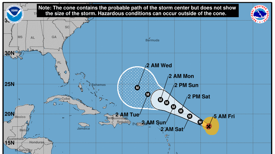
For now, Lee is an “incredibly powerful” Category 5 storm with 165 mph winds, the National Hurricane Center says. But thankfully, it’s not currently threatening to make landfall anywhere in the U.S. or the Caribbean.
That doesn’t mean no one will experience any effects from Lee. The hurricane’s sheer power will bring dangerous beach conditions to Puerto Rico and other islands on Friday and Saturday. By Sunday, “most of the U.S. East Coast” will see dangerous rip currents, according to the NHC.
The latest forecast sees the heart of the storm staying well north of the Leeward Islands, the Virgin Islands and Puerto Rico as it moves west-northwest across open water this weekend and early next week.
Next for Lee: more power, then growth
It took just 24 hours for Lee’s maximum sustained winds to roar from 80 mph to 160 mph, from late Wednesday to late Thursday. It is now roiling the ocean, with waves peaking between 45 and 55 feet near its center, according to the NHC.
If you’re thinking it’s early for a hurricane to reach this stature, you’re not wrong. As hurricane expert Michael Lowry says, “Lee is the farthest southeast we’ve ever observed a Category 5 hurricane in the Atlantic since records began 172 years ago.”
Hurricane #Lee is in elite company tonight. Fewer than 1% of all tropical cyclone “fixes” ever attain Category 5 strength. Lee is the farthest southeast we’ve ever…
Read the full article here
Leave a Reply