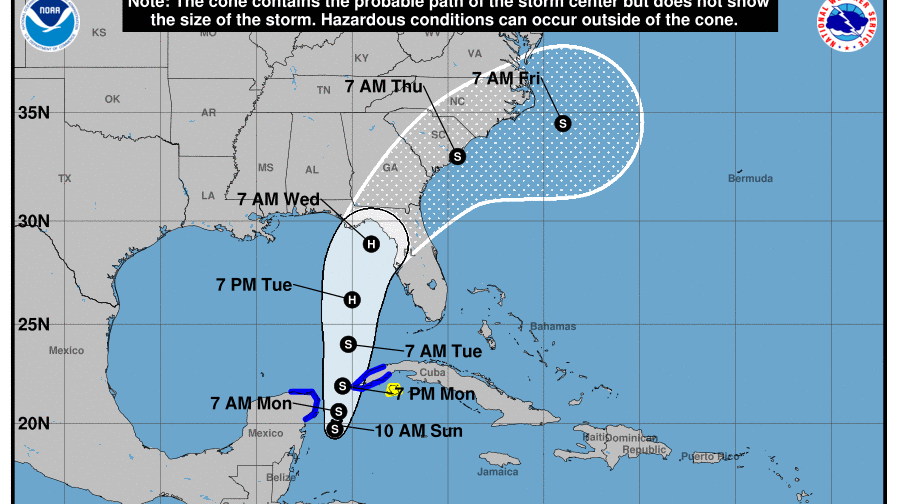

A graphic from the National Hurricane Center shows a projected path of Tropical Storm Idalia.
National Hurricane Center
A tropical storm churning in the Gulf of Mexico could reach hurricane strength and is expected to begin moving north toward Florida and the southeastern U.S. in the coming days.
Forecasters say the system, known as Tropical Storm Idalia, could intensify in the warm Gulf of Mexico waters and has the potential to clobber western Florida and the Panhandle with severe weather starting on Tuesday.
“If you’re anywhere along the western Florida peninsula — so let’s say from about Fort Myers northward to the Panhandle — you really got to be paying attention, even if you’re outside of the cone,” National Hurricane Center deputy director Jamie Rhome said in a video briefing Sunday morning.
At 11:15 a.m. EDT, Idalia was located about 80 miles east-southeast of Cozumel, Mexico, moving east at 2 mph with its highest sustained winds at 40 mph, the NHC said.
Florida Gov. Ron DeSantis has declared a state of emergency for 33 counties and authorities there have begun preparing storm response resources, such as high-water vehicles and boats.
Florida’s Division of Emergency Management is encouraging residents with vehicles to keep their gas tanks at least half-full in case officials order any evacuations.
If Idalia becomes a hurricane when its sustained winds reach more than 75 mph and comes ashore in the U.S. at that strength, it would be the first Atlantic hurricane to strike the U.S. this year.
But it’s still unclear exactly how strong Idalia will grow and what path it will take.
Tropical storm warnings were in effect Sunday for parts of Mexico and western Cuba with the potential for…
Read the full article here
Leave a Reply